


Mining is as much about gathering information as it is gathering metals and minerals. Similarly, as heavy equipment and extraction techniques have evolved over the years, so, too, have information-capturing techniques and technologies. Highwall mining, in particular, has come a long way, and modern mining operations are reaping the benefits with new mining solutions.
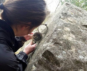
Traditionally, highwall mining information gathering primarily took place on foot, with geologists and geotechnical engineers walking up to the wall and conducting field research by hand. The process was reasonably effective when they could get close to the wall, but that was neither efficient nor safe even under ideal circumstances.
The next logical step in the highwall mining technology evolution was laser scanning, and the ability to digitally capture highwall data offered significant operational advantages. Laser scanners in mining are not without their drawbacks, however. The equipment is expensive and requires a high degree of technical skill to operate, and the possibility of shadows and blank spots in the point cloud means scans could miss valuable data.
The need to conduct scans relatively close to walls is at odds with essential safety measures in mining, and it also limits how much of the wall can be captured at once. As highwall mining technology continues to shift, we predict that a bevy of user-friendly solutions will emerge.
-2.jpg?width=4032&name=Image%20from%20iOS%20(10)-2.jpg)
A Step Up
When drones and unmanned aerial vehicles (UAVs) became widely available, it was immediately apparent that these tools could overcome some of the challenges facing the mining industry. They borrow some of the principles adopted in other highwall mining technologies such as laser scanners, but unmanned flight enables an unprecedented degree of accessibility. The most effective safety measures in mining don’t just reduce risk; they remove personnel from harm’s way entirely. Drone usage has been an enormous step in the right direction, but there’s still room for improvement.
Early iterations of drone technology often required the placement of ground control points (GCPs) to maintain a high degree of accuracy. These GCPs were commonly placed by hand, which somewhat compromised the safety benefits of UAV use. Resolution has also been an issue with drone scanning, and it’s historically been insufficient for taking structure measurements of sub-bench scale features.
Fortunately, we've seen several highwall mining technologies lead to marked improvements in the utility of drones in mining, including:
One: Automated Flight Planning
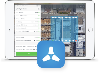 Automated mining equipment allows an operation to reduce reliance on human personnel for mundane and time-consuming tasks. The Skycatch Flight1 app can automatically generate flight plans from takeoff to landing and includes a proprietary Highwall Scanning Feature that safely guides the drone along the pit wall so it can capture hi-resolution images. With these advanced terrain-following technologies, the drone will thoroughly and accurately map out the highwall.
Two: Advanced Data Processing
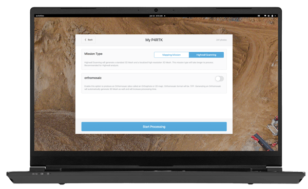
Capturing data is only the first step toward unlocking insights contained within it. The Skycatch Vision Engine™ for advanced highwall processing uses proprietary technology to produce high-resolution images from large photogrammetry datasets. The tool is available in the cloud or on-prem depending on the mining location's requirements or internet access.
Three: Next-Generation Drones
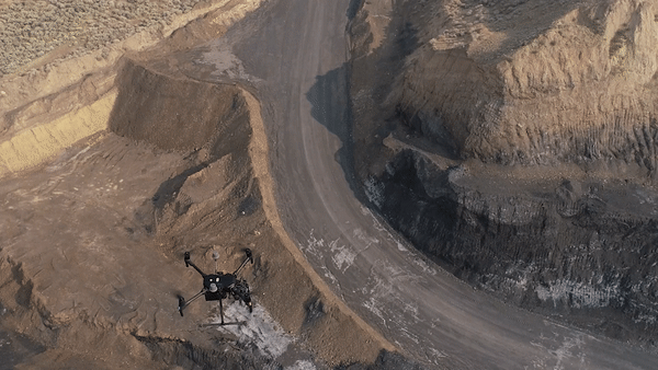
Real-Time Kinematic (RTK) drones like the DJI P4RTK and M210RTK V2 used in conjunction with the Skycatch Edge1 smart base station provide geo-referenced photo datasets accurate down to 5 centimeters or less. These products are excellent complements to the Advanced Highwall Scanning Technology from Skycatch to create high-resolution, high-accuracy point clouds and 3D models that geologists, geotechnical engineers, and other personnel can leverage.
The Skycatch team is pioneering UAV applications and data-imaging technologies to overcome challenges facing the mining industry and highwall mining specifically. With our propriety mining automation software and advanced image processing techniques, your highwall mining operation can unlock increased efficiency, improved safety, and the data you need to boost your bottom line.
Did we pique your interest in more highwall mining technology that is on the horizon? Visit us at Skycatch to learn more.

