


Traditionally, open pit highwalls have been expensive, time-consuming, and dangerous to scan. However, despite the financial costs, burdens of time, and risk of bodily injury to personnel, there’s no doubt that highwall scanning is imperative for enabling your geologists and geotechnical engineers to do their jobs effectively.
-2.png?width=2792&name=image%20(7)-2.png) A highwall scan allows geologists and geotechnical engineers to identify rock types and mineral resources, and to assess the stability of the terrain.
A highwall scan allows geologists and geotechnical engineers to identify rock types and mineral resources, and to assess the stability of the terrain.
They must pinpoint specific features with the greatest degree of accuracy, so that when the actual mining begins, everything is where it is expected to be. As a result, the mining of a pit wall is safer and more efficient.
Up until recently, the main source of data for highwalls has been through the use of terrestrial LiDAR scanners. The drawback of these LiDAR scanners is that, when it comes to mapping highwalls, accessibility is limited, and they just don’t have the range to capture accurate data across whole kilometers of space. It takes your surveyors countless hours to set up and capture all of the data your team requires. And, often due to safety concerns, they are unable to use the scanner at all to get the data they need.
Skycatch offers a quicker, safer and more accessible option that provides precision 3D models of your highwalls for a fraction of the overall cost of a laser scanner. It includes a full range of advanced drone-based technology now available for capturing, processing and analyzing the highest resolution outputs of your highwalls safer, faster and easier than ever. Surveyors, who are often in high demand at the mine sites, are no longer a bottleneck.
And, it all starts with the latest version of the Skycatch drone mission planner for iOS called Flight1 v4.0.0.
 What is Flight1?
Skycatch Flight1 is an autonomous flight app that helps you to plan and execute missions for multiple drones including the Skycatch Explore1 and the DJI P4 & P4P drones.
With the latest version of Flight1 v4.0.0,
the DJI P4RTK and M210RTK drones
are also supported.
%20(1).png?width=548&name=image%20(9)%20(1).png)
The Flight1 app has long been the “go-to” drone mission planning app for automated aerial mapping from takeoff to landing. Flight1 will automatically generate a flight plan, including optimal waypoints, speed, and overlap for you. Or you can customize your flight settings to ensure you capture the exact geotagged images you need.
What now makes Flight1 also unique for highwall capture, however, is its new proprietary, automated Highwall Scanning feature. Its terrain following capabilities means the drone safely flies close to the pit wall. In addition, the dynamic gimbal control ensures the camera consistently faces the wall in order to capture the best high resolution images possible.
How Does the Terrain Following and Dynamic Camera Control Work?
Automatically capturing your highwall dataset is simplified with the release of Flight1 version 4.0.0. Available with the release (currently upon request*) is a one-of-a-kind terrain following technology developed by Skycatch engineers specifically for mining companies who wish to use it to scan vertical surfaces like pit walls.
This terrain following feature is enabled by the use of a digital surface model (DSM) file that informs the app about the terrain elevations. Prior to your 3D highwall scanning mission, this DSM can be captured and processed using the combination of your Flight1 app, your drone and the Skycatch Vision Engine for processing available on Edge1, in the cloud or on-premise. Alternatively, you can create a DSM from an existing point cloud, if available.
Flight1 uses this terrain data to automatically
adjust the flight path and camera angle.
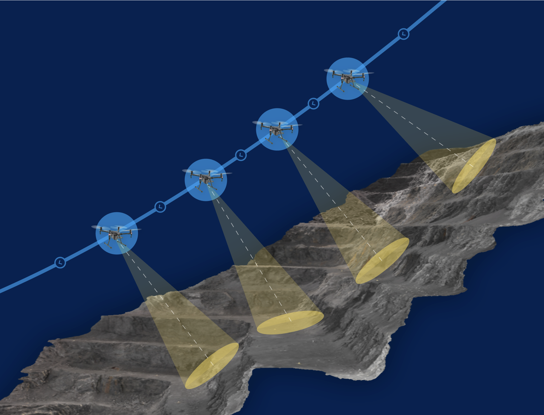
It ensures the camera is at the right distance and angle compared to the wall for best capture. There is no manual manipulation required and, as usual with the Skycatch technology, you do not need additional ground control points to meet your accuracy requirements. Yet, the image data you get will be of the highest quality for processing precise, high resolution 3D models.
*The Highwall Scanning feature of Flight1 version 4.0.0 is currently only available upon request. To see if you are eligible to enable this new feature or to learn more about the full highwall mapping capabilities from Skycatch, please fill out the contact form on our website or email sales@skycatch.com.
How Do You Process the Data You Have Captured?
When used as part of the High Precision Package (HPP) for Mining from Skycatch, your geotagged drone images are processed in the cloud (or on-premise with the Skycatch Vision License) and turned into orthophotos, point clouds, 3D mesh and more. Measure, overlay, markup, analyze and share your processed data using Skycatch Data Hub or other mining software, like Maptek or Leapfrog, that ingest point clouds.
Be sure to stay tuned for future posts with more details behind the processing and analysis of your 3D open pit highwall scans.
Ready to Revolutionize the Way You Scan Highwalls?
Get in touch via the contact form at the bottom of our homepage to discuss the solutions that would best suit your requirements.

