


Construction and mining work happens in person. While many professions have taken to Zoom meetings and company chats to survive, companies are making changes to safely continue work where possible, or to demobilize projects that are not considered essential. In both cases, builders and miners across the globe continue to execute.
On site, companies are taking actions to prevent the spread of COVID-19. Off-site, however, critical functions like engineering, VDC, accounting, and scheduling have been forced to maintain productivity at home. Deprived of the ability to see, feel, and experience their sites, companies are turning to reality capture technology to make critical decisions that impact the viability of their projects.
Skycatch has enabled construction and mining teams around the globe to perform virtual site visits and quantitatively understand their projects and sites for over 7 years. Now, with travel restrictions in place, customers are using our data more than ever. Drones are operated by a single person maintaining appropriate social distance: our high precision PPK/RTK-GPS means comprehensive, quantifiable project status can be collected accurately without ever setting foot on site.
“The good thing about using UAVs for site capture is that you run no risk; you have zero physical contact with people.”
- Sr. Field Engineer, ENR Top 10 General Contractor
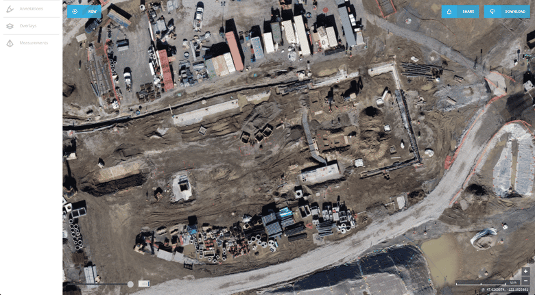
From the field to the cloud and into our customers’ home offices, we make that data available online in an easy-to-use browser interface that can be used by superintendents, engineers, geotechs and project executives alike. Granting access to all stakeholders keeps everyone on the same page, and productivity tools like annotations, CAD overlays, and 3D measurement enable collaborative decision making based on up-to-date site information, from home or abroad.
“Anything visual is 100x better than what we were doing previously. I can check spoils, audit grades and slopes. Being able to drop a pin on a map and export that to a PDF knowing exactly where it is is immensely helpful.”
- Mining Survey Technician, Top 25 Mining Company
New definitions of essential businesses are being put into effect, and the value of up-to-date project snapshots becomes essential. In one use case, a customer’s high-value site has kept a security crew in place, and with daily data-capture flights, the security team can track assets in case any equipment or material is moved. And when the company restarts the project, all stakeholders can easily understand the state of progress and where to begin where they left off.
- William Pryor, Manager, Enterprise Solutions
Skycatch is offering special promotions during this time for new users, so schedule a Data Hub demo with our team today. Fill out the form below and we'll contact you to let you know about how our 3D analytics and productivity tools enable team collaboration and authoritative decision making -- whether you are in the field, or working from your home office.

